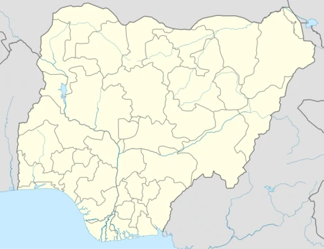
Akwa Ibom State
Nigeria's highest oil-producing state, created in 1987.

via Wikipedia: Akwa Ibom State · see source
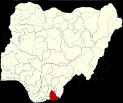
Akwa Ibom is a state in the South-South geopolitical zone of Nigeria. It borders Cross River State to the east, Rivers State and Abia State to the west and north-west, and the Atlantic Ocean to the south. The state takes its name from the Qua Iboe River which bisects the state before flowing into the Bight of Bonny. Akwa Ibom was split from Cross River State in 1987. The state has 31 local government areas, and its capital is Uyo. Akwa Ibom has an estimated population of over 8.5 million. Economically, Akwa Ibom State is based around the production of crude oil and natural gas as the highest oil-producing state in the country. Despite its vast oil revenues, Akwa Ibom has the seventeenth highest Human Development Index in the country in large part due to years of systemic corruption.
- highest_oil_producer
- highest oil-producing state in the country
- population_2006_census
- over 8.5 million (estimated)
- population_2022_projected
- over 8.5 million (estimated)
Verified Timeline
Lore & Background
In the pre-colonial period, what is now Akwa Ibom State was divided into various city-states like the Ibom Kingdom and Akwa Akpa before they later became a British protectorate in 1884 as a part of the Oil Rivers Protectorate. Prior to British colonization, no central government had existed among the people; the various ethnic peoples were largely organized into clan communities based on kinship and relations. Several Scottish missionaries went to Calabar in 1848, and Ibono in 1887. The British government did not attempt to establish more control over the area until 1904, when they organized the Enyong Division, encompassing the area of the current state, with headquarters at Ikot Ekpene, a predominately Annang city. Noted Africanist Kaanan Nair noted this city as the cultural and political capital of the Annang people. The creation of Enyong Division encouraged collaboration among the numerous minority ethnic groups, who created the Ibibio Welfare Union, later renamed Ibibio State Union. This social organization was first established as a local development and improvement forum for educated African persons and groups who in 1929 were still excluded from the colonial administration. In the early 1900s, the British gained formal control before incorporating the protectorate (renamed the Niger Coast Protectorate) into the Southern Nigeria Protectorate, which later merged into British Nigeria. After the merger, much of modern-day Akwa Ibom became a centre of anti-colonial resistance during the Women's War and political activism through the Ibibio State Union. After independence in 1960, the area was part of the post-independence Eastern Region until 1967 when the region was split and the area became part of the South-Eastern State. Less than two months afterwards, the Eastern Region attempted to secede as the state of Biafra; in the three-year long Nigerian Civil War, now-Akwa Ibom was hard-fought over in the prelude to the Invasion of Port Harcourt. At the war's end and the reunification of Nigeria, the South-Eastern State was reformed until 1976 when it was renamed Cross River State. Eleven years later, Cross River State was divided on 23 September 1987, by the Military Administration of General Ibrahim Badamosi Babangida, resulting in the creation of Akwa Ibom State. Uyo was chosen as the state capital in order to encourage development in all regions of the state.
Reader's Guide
Akwa Ibom State is Nigeria's highest oil-producing state, with oil-producing local government areas including Esit Eket, Eket, Onna, Mkpat Enin, Ikot Abasi, Ibeno, Mbo, and Eastern Obolo. Key minor industries involve agriculture, with substantial cocoyam, yam, and plantain crops along with fishing and heliciculture. Despite its vast oil revenues, years of systemic corruption have resulted in such revenues being diverted from improving infrastructure, education and welfare of the people, leaving the state with the seventeenth highest Human Development Index in the country. Geographically, the state is divided between the Central African mangroves in the coastal far south and the Cross–Niger transition forests in the rest of the state. Important geographical features include the Imo and Cross rivers which flow along Akwa Ibom's eastern and western borders respectively, while the Kwa Ibo River bisects the state before flowing into the Bight of Bonny. In the southeast corner is the Stubb Creek Forest Reserve, a heavily threatened wildlife reserve containing declining crocodile, putty-nosed monkey, red-capped mangabey, and Sclater's guenon populations along with potentially extirpated populations of African leopard and Nigeria-Cameroon chimpanzee. Offshore, the state is biodiverse with large fish populations alongside various cetacean species, including bottlenose dolphins, pantropical spotted dolphins, humpback whales, and killer whales. The main ethnic groups are the Ibibio, Annang, and Oron peoples. Politics in the state are dominated by these three groups, with the Ibibio remaining the majority and holding sway since creation. The people are predominantly Christians.
Did You Know?
- Akwa Ibom was split from Cross River State on 23 September 1987 by the Military Administration of General Ibrahim Badamosi Babangida.
- The state takes its name from the Qua Iboe River, which bisects the state before flowing into the Bight of Bonny.
- Akwa Ibom has 31 local government areas, and its capital is Uyo.
- The Stubb Creek Forest Reserve in the southeast corner contains potentially extirpated populations of African leopard and Nigeria-Cameroon chimpanzee.
- Offshore cetacean species in Akwa Ibom include bottlenose dolphins, pantropical spotted dolphins, humpback whales, and killer whales.
Geography & Natural Wealth
Akwa Ibom occupies Nigeria's South-South zone, flanked by Cross River State on the east, Rivers and Abia to the west and north-west, and open Atlantic waters to the south. The Qua Iboe River slices through the state's heart before emptying into the Bight of Bonny, while the Imo and Cross rivers mark its eastern and western boundaries. The far southern coast is a tapestry of Central African mangroves, giving way inland to the Cross–Niger transition forests that blanket the remainder of the territory. The Stubb Creek Forest Reserve in the southeast corner is a heavily threatened sanctuary, home to shrinking populations of crocodiles, putty-nosed monkeys, red-capped mangabeys, and Sclater's guenons, with African leopards and Nigeria-Cameroon chimpanzees possibly already lost. Beyond the shoreline, the offshore waters support abundant fish stocks and a remarkable cetacean community including bottlenose and pantropical spotted dolphins, humpback whales, and even killer whales. More than 8.5 million people call this landscape home across 31 local government areas, with Uyo serving as the state capital.
The Oil Paradox
Akwa Ibom commands a singular position in Nigeria's energy sector: it is the country's highest-producing state for both crude oil and natural gas. Eight local government areas—Esit Eket, Eket, Onna, Mkpat Enin, Ikot Abasi, Ibeno, Mbo, and Eastern Obolo—anchor the hydrocarbon economy. Complementing this, the state sustains meaningful agricultural output in cocoyam, yam, and plantain, alongside fishing and heliciculture as smaller but vital livelihoods. Yet the numbers tell a troubling story. Despite generating the nation's largest oil revenues, Akwa Ibom sits at seventeenth place in the national Human Development Index ranking. The underlying cause is widely attributed to prolonged systemic corruption that has redirected resource wealth away from public infrastructure, schooling, and social welfare. The result is a stark and persistent gap between the state's natural resource endowment and the lived material conditions of its people, making it one of Nigeria's most visible examples of the resource-curse dynamic.
Peoples & Linguistic Mosaic
The population of Akwa Ibom is woven from several closely related ethnic communities. The Ibibio, Annang, and Oron peoples form the principal groups, concentrated in the state's North-East, North-West, and Southern zones respectively, and all share deep cultural and linguistic kinship with the Efik people of neighboring Cross River State. The state is home to slightly more than twenty distinct first languages, each tied to particular local government areas. Annang spans Abak, Essien Udim, Ikot Ekpene, Oruk-Anam, and Ukanafun; Ibibio stretches across a dozen LGAs from Etinan to Onna; while smaller tongues such as Ebughu, Efai, Ekid, Okobo, and Uda occupy narrower geographic pockets. One researcher has proposed that only about ten true languages exist, reclassifying several as dialects, though the criteria for that distinction are not clearly articulated. This rich mosaic reflects centuries of clan-based social organization rooted in kinship and local identity rather than any single centralized authority.
From City-States to Statehood
Long before European contact, the territory now known as Akwa Ibom was a patchwork of city-states including the Ibom Kingdom and Akwa Akpa, with no overarching central government. Daily life was organized around clan communities bound by kinship. Scottish missionaries reached Calabar in 1848 and Ibono by 1887, but formal British administrative control arrived in 1904 with the establishment of the Enyong Division, headquartered in the Annang city of Ikot Ekpene. That colonial structure inadvertently encouraged cross-ethnic collaboration, prompting the founding of the Ibibio Welfare Union—later the Ibibio State Union—as a development forum for educated Africans shut out of colonial governance. After Nigeria's 1960 independence, the area sat within the Eastern Region until 1967, when it was reassigned to the South-Eastern State. The subsequent Biafran secession and three-year civil war brought fierce fighting through the region during the prelude to the Invasion of Port Harcourt. In 1987, Akwa Ibom was finally carved out of Cross River State to become its own political entity.
Gallery
Frequently Asked Questions
Who is Akwa Ibom State?
Akwa Ibom is a South-South Nigerian state headquartered in Uyo, carved out of Cross River State in 1987 and named after the Qua Iboe River that flows through its territory. It is home to roughly 5.5–6 million people as of recent projections.
What are Akwa Ibom State's powers and role?
Its primary 'power set' is heavy crude-oil extraction, making it one of the country's key energy producers alongside Rivers and Delta. In practice, however, it is not universally ranked the top oil-producing state, and much of that wealth has been eroded by systemic corruption rather than channeled into broad development.
Where did Akwa Ibom State come from?
Akwa Ibom was created in 1987 when the federal government split it off from the larger Cross River State, giving the new entity its own capital in Uyo. Its name derives directly from the Qua Iboe River, a geographic landmark that runs through the region.
Why is Akwa Ibom State important to the broader story?
As a major oil-producing state in the South-South geopolitical zone, it plays a significant role in Nigeria's energy output and regional economy. Its population has nearly doubled since the 2006 census (from about 3.9 million to an estimated 5.5–6 million), making its governance and resource management increasingly consequential.
How does Akwa Ibom State's story end?
There is no definitive 'ending' yet, but the current arc is complicated: despite its oil wealth, Akwa Ibom sits at the seventeenth position on Nigeria's Human Development Index, a gap fans and analysts attribute to decades of mismanagement and corruption. The state's ongoing narrative is defined by the tension between its resource potential and the quality of life its residents actually experience.
More in Nigerian States 1-24
Related in Nigerian States
Links follow this subject's own source article.
Elsewhere in the Nigerian States universe
Spotted an error? Know more?
This is a living reference — every entry is fact-audited, and reader corrections feed straight into our audit queue. Suggest an edit · See this site's audit record