Cross River State
A Nigerian state formed in 1967, named after the Cross River.

via Wikipedia: Cross River State · see source
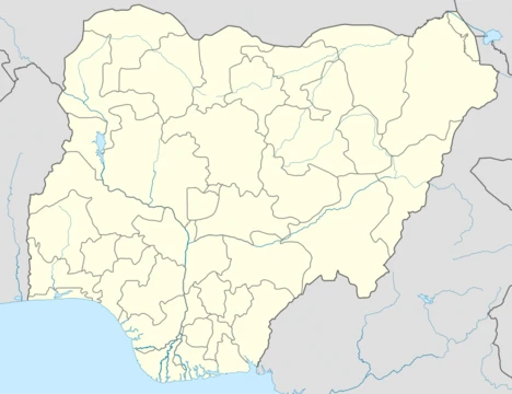
Cross River State is a state in the South-South geopolitical zone of Nigeria. Named for the Cross River, the state was formed from the eastern part of the Eastern Region on 27 May 1967. Its capital is Calabar, and it is bordered to the north by Benue State, to the west by Ebonyi State and Abia State, and to the southwest by Akwa Ibom State while its eastern border forms part of the national border with Cameroon. Originally known as the South-Eastern State before being renamed in 1976, Cross River state formerly included the area that is now Akwa Ibom State, which became a distinct state in 1987. Geographically, the state is mainly divided between the Guinean forest–savanna mosaic in the far north and the Cross–Sanaga–Bioko coastal forests in the majority of the interior, with smaller ecoregions including the Central African mangroves and montane Cameroonian Highlands forests.
- created
- 27 May 1967
- capital
- Calabar
- area
- 20,156 square kilometres
- population
- over 3.8 million (as of 2016)
- geopolitical_zone
- South-South
- former_name
- South-Eastern State (until 1976)
Verified Timeline
Lore & Background
Cross River State was created on 27 May 1967 from the former Eastern Region, Nigeria, by the General Yakubu Gowon regime. Its name was changed to Cross River state in the 1976 state creation exercise by the then General Murtala Mohammed regime from South Eastern State. The present-day Akwa Ibom State was excised from it in the state creation exercise of September 1987 by the then regime of General Ibrahim Babangida. The struggle for a new state creation started in 1980 in the reign of president Shehu Shagari where Senator Joseph Oqua Ansa (Mon) the senator representing Calabar senatorial district then was at the helm of affairs. Its capital is Calabar. Its major towns are Calabar Municipality, Akamkpa, Biase, Calabar South, Ikom, Igede, Obubra, Odukpani, Ogoja, Bekwarra, Ugep, Obudu, Obanliku, Akpabuyo, Ofutop, Iso-bendghe, Danare, Boki, Yala, Bendeghe Ekiem, Etomi, Ediba, Itigidi, Ugep, Ukpe and Ukelle. The state has many governors and administrators including Udoakaha J. Esuene, Paul Omu, Tunde Elegbede, Clement Isong, Donald Etiebet, Daniel Archibong, Ibim Princewill, Ernest Attah, Clement Ebri, Ibrahim Kefas, Gregory Agboneni, Umar Faoruk Ahmed, Christopher Osondu, Donald Duke, Liyel Imoke and Benedict Ayade. The current Governor is Bassey Edet Otu, who was sworn into office on 29 May 2023. He was elected for a four-year term in office under the platform of All Progressive Congress (APC).
Reader's Guide
Cross River State holds historical significance as a center of anti-colonial resistance during the Women's War and as a site of trade through the international seaport at Calabar. After independence in 1960, the area of now-Cross River was a part of the post-independence Eastern Region until 1967 when the region was split and the area became part of the South-Eastern State. Less than two months afterwards, the Igbo-majority former Eastern Region attempted to secede as the state of Biafra; in the three-year long Nigerian Civil War, Calabar and its port was hard fought over in Operation Tiger Claw while people from Cross River were persecuted by Biafran forces as they were mainly non-Igbo. At the war's end and the reunification of Nigeria, the South-Eastern State was reformed until 1976 when it was renamed Cross River State. Eleven years later, Cross River State was divided with western Cross River being broken off to form the new Akwa Ibom State. The state formerly contained the oil-producing Bakassi Peninsula, but it was ceded to Cameroon under the terms of the Greentree Agreement. As an agricultural state, the Cross River's economy partially relies on crops, such as cocoyam, rubber, oil palm, yam, cocoa, cashews, and plantain crops, along with fishing. Key minor industries involve tourism in and around the wildlife reserves along with the historic Ikom Monoliths site, Calabar Carnival, and Obudu Mountain Resort. Cross River state has the joint-thirteenth highest Human Development Index in the country and numerous institutions of tertiary education.
Did You Know?
- Cross River State was originally known as the South-Eastern State before being renamed in 1976.
- The state formerly included the area that is now Akwa Ibom State, which became a distinct state in 1987.
- During the Nigerian Civil War, Calabar and its port were hard fought over in Operation Tiger Claw.
- The state formerly contained the oil-producing Bakassi Peninsula, ceded to Cameroon under the Greentree Agreement.
- Cross River State has the joint-thirteenth highest Human Development Index in the country.
Geography & Living Heritage
Cross River State takes its name from the great river that slices through its interior before curving to form much of the western boundary and emptying into the Cross River Estuary. Two other notable waterways, the Calabar and Great Kwa rivers, rise in the inland Oban Hills, flank the city of Calabar, and also drain into the same estuary. The state spans roughly 20,156 square kilometres, making it the nineteenth largest of Nigeria's thirty-six states, and sits within the Niger Delta coastal region. Its ecological tapestry is remarkably varied: the far northern reaches belong to the Guinean forest-savanna mosaic, the bulk of the interior falls within the Cross-Sanaga-Bioko coastal forests ecoregion, the extreme south hosts Central African mangroves, and the far northeast touches the montane Cameroonian Highlands forests. Within the forested interior lie several protected areas—Cross River National Park, Afi Mountain Wildlife Sanctuary, and Mbe Mountains Community Forest—that shelter some of Nigeria's last remaining Cross River gorillas, Nigeria-Cameroon chimpanzees, African forest elephants, and drills, alongside Preuss's red colobus, African forest buffalo, bat hawk, tree pangolin, grey-necked rockfowl, and West African slender-snouted crocodile.
From Protectorate to Republic: A Turbulent Political Journey
Before European contact, the territory was a patchwork of ethnic polities: some communities aligned with the Aro Confederacy, while the Efik built the independent city-state of Akwa Akpa, later known as Old Calabar. Britain declared a protectorate there in 1884, designating it the capital of the Oil Rivers Protectorate, though formal control over the whole region was not secured until the early 1900s. The area was subsequently renamed the Niger Coast Protectorate, absorbed into the Southern Nigeria Protectorate, and merged into British Nigeria. Under colonial rule, the region became a centre of anti-colonial resistance, particularly through the Women's War, while Calabar's seaport served as a key international trade hub. After independence in 1960, the area sat within the Eastern Region until 27 May 1967, when the Gowon regime carved it into the South-Eastern State. Two months later, the Igbo-majority former Eastern Region attempted secession as Biafra. In the ensuing three-year war, Calabar and its port were fiercely contested in Operation Tiger Claw, and the area's predominantly non-Igbo residents faced persecution from Biafran forces. After reunification, the South-Eastern State was reconstituted, renamed Cross River State in 1976, and then split in 1987 when its western portion became Akwa Ibom State. The oil-producing Bakassi Peninsula was also ceded to Cameroon under the Greentree Agreement.
A Mosaic of Peoples
Cross River State is home to a rich tapestry of ethnic communities. The Efik dominate the riverside south and the city of Calabar, while the Ekoi, also called Ejagham, inhabit the inland south. The central region is shared by the Akunakuna, Boki, Bahumono, and Yakö (Yakurr) peoples. In the north, the Bekwarra, Bette, Igede, Mbube, and Ukelle (Kukele) communities make their home. This diversity is reflected in the state's major towns, which stretch from Calabar Municipality and Akamkpa in the south to Ogoja, Igede, and Ugep in the north, passing through Ikom, Obudu, and Boki in between. With an estimated population exceeding 3.8 million as of 2016, Cross River ranks twenty-seventh among Nigeria's thirty-six states in size of population. Despite its modest headcount, the state holds the joint-thirteenth highest Human Development Index in the country and hosts numerous institutions of tertiary education, underscoring a commitment to human capital that extends well beyond its agricultural roots.
Fields, Festivals, and the Road Ahead
As an agricultural state, Cross River's economy draws heavily on the land and water. Staple and cash crops such as cocoyam, yam, plantain, oil palm, rubber, cocoa, and cashews form the backbone of rural livelihoods, complemented by fishing in the rivers and estuaries. Beyond agriculture, the state has cultivated a distinctive tourism identity. The historic Ikom Monoliths site, the vibrant Calabar Carnival, and the Obudu Mountain Resort draw visitors who also explore the wildlife reserves that protect the state's extraordinary biodiversity. Governance has passed through many hands over the decades, with governors and administrators ranging from Udoakaha J. Esuene and Paul Omu in the early post-creation years to Donald Duke, Liyel Imoke, and Benedict Ayade in more recent times. The current governor, Bassey Edet Otu, was sworn in on 29 May 2023 on the platform of the All Progressive Congress for a four-year term. The state's political trajectory—from the 1980 state-creation advocacy led by Senator Joseph Oqua Ansa to the present—reflects a community that has continually negotiated its place within the Nigerian federation.
Gallery
Frequently Asked Questions
Who is Cross River State?
Cross River State is a Nigerian state in the South-South zone, named after the river that flows through its territory. It was carved from the eastern part of the Eastern Region on 27 May 1967 and went by the name South-Eastern State until 1976.
What is Cross River State's capital and size?
Calabar serves as the capital, and the state covers roughly 20,156 square kilometres with a population exceeding 3.8 million people as of the 2016 census.
How was Cross River State formed?
It was established on 27 May 1967 by splitting off the eastern portion of the Eastern Region into a separate state. At that time it included a far larger area, encompassing what is now Akwa Ibom State before that region broke away in 1987.
Why is Cross River State important?
The state is ecologically significant, home to protected areas such as Cross River National Park that shelter rare species. It also carries deep historical weight as a key site in both pre-colonial and colonial-era narratives of southeastern Nigeria.
What borders Cross River State?
It shares land boundaries with Benue, Ebonyi, Abia, and Akwa Ibom states, while its eastern edge forms part of Nigeria's international border with Cameroon.
More in Nigerian States 1-24
Related in Nigerian States
Links follow this subject's own source article.
Elsewhere in the Nigerian States universe
Spotted an error? Know more?
This is a living reference — every entry is fact-audited, and reader corrections feed straight into our audit queue. Suggest an edit · See this site's audit record