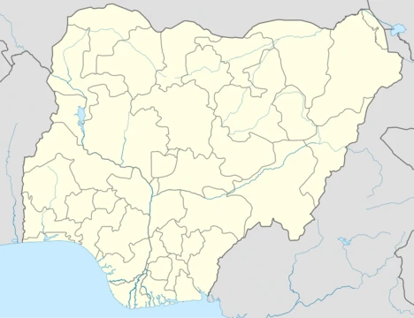
Borno State
Nigeria's only state bordering three countries, second largest in area, and epicenter of the Boko Haram insurgency since 2009.

via Wikipedia: Borno State · see source
Borno is a state in the North-East geopolitical zone of Nigeria. It is bordered by Yobe to the west, Gombe to the southwest, and Adamawa to the south, while its eastern border forms part of the national border with Cameroon. Its northern border forms part of the national border with Niger and its northeastern border forms all of the national border with Chad. It is the only Nigerian state to border up to three countries. It takes its name from the historic emirate of Borno, with the emirate's old capital of Maiduguri serving as the capital city of Borno State. The state was formed on 3 February 1976 when the former North-Eastern State was broken up. It originally included the area that is now Yobe State, which became a distinct state in 1991. Borno is the second largest in area of the 36 states, only behind Niger State. Despite its size, the state is the eleventh most populous with an estimated population of about 5.86 million as of 2016.
- area_rank
- Second largest in Nigeria (behind Niger State)
- population_2016
- Approximately 5.86 million
- capital
- Maiduguri
- major_religion
- Islam (~85%)
- formed
- 3 February 1976
- bordering_countries
- Cameroon, Niger, Chad
Verified Timeline
Lore & Background
From the 700s, what is now Borno State was within the territory of the Kanem Empire, an empire spanning from modern-day southern Libya (Fezzan) south through most of now-Chad into modern-day Borno State. In the late 1300s, the Kanem Empire was forced to move after unsuccessful wars, becoming the Bornu Empire before regaining strength and ruling the wider area for the next 500 years. It was not until the early 1800s when the Fulani jihad significantly weakened the Empire, that Bornu began to decline. Much of modern-day southern Borno State was seized in the wars and incorporated into the Adamawa Emirate under the Sokoto Caliphate. About 80 years later, Rabih az-Zubayr, a Sudanese warlord, conquered the Empire and ruled until he was killed by French forces in the 1900 Battle of Kousséri. The Adamawa Emirate was also defeated by colonial powers, losing the Adamawa Wars to Germany and the British Empire. Both Rabih's lands (later reconstituted as the Borno Emirate) and the Adamawa Emirate were then divided among colonial powers with modern-day Borno State being split between Germany and the British Empire. The British-controlled area was incorporated into the Northern Nigeria Protectorate which later merged into British Nigeria before becoming independent as Nigeria in 1960. The German-controlled area (territory along the modern-day border with Cameroon) formed Deutsch-Bornu as a part of German Kamerun until allied forces invaded and occupied Kamerun during the Kamerun campaign of World War I. After the war, what is now the eastern periphery of Borno State became a part of the Northern Cameroons within the British Cameroons until 1961, when a referendum led to a merger with Nigeria.
Reader's Guide
Borno State as a territory has been inhabited for centuries by various ethnic groups, including the Dghwede, Glavda, Guduf, Laamang, Mafa, and Mandara in the central region; the Afade, Yedina (Buduma), and Kanembu in the extreme northeast; the Waja in the extreme south; and the Kyibaku, Kamwe, Kilba, and Margi groups in the south while the Kanuri and Shuwa Arabs live throughout the state's north and centre. Religiously, the vast majority of the state's population (~85%) are Muslim with smaller Christian and traditionalist minorities (especially in the south) at around 7% each. Geographically, the state is divided between the semi-desert Sahelian savanna in the north and the West Sudanian savanna in the centre and south with a part of the montane Mandara Plateau in the southeast. In the far northeast of the state is the Nigerian portion of Lake Chad and the Lake Chad flooded savanna ecoregion; the lake is fed by the Yobe River which forms the state's border with Niger until it reaches the lakebed. In the centre of the state is part of the Chad Basin National Park, a large national park that contains populations of black crowned crane, spotted hyena, patas monkey, and roan antelope along with transient herds of some of Nigeria's last remaining African bush elephants. However, a section of the park, the Sambisa Forest, was taken over during the Boko Haram insurgency in the early 2010s forcing many fauna to flee; large animals were not seen until 2019 and 2020 when a massive herd of migratory elephants returned to Borno. The state became the epicentre of the Islamist group Boko Haram since it began its insurgency in 2009. From 2012 to 2015, the insurgency escalated dramatically with much of the state falling under the control of the group, which soon became the world's deadliest terror group in 2015 and forced millions from their homes. Following a 2015 mass multinational offensive along with infighting within the terrorists between the original Boko Haram group and the Islamic State – West Africa Province breakaway, the group was forced from its strongholds into the Sambisa Forest and some islands in Lake Chad by 2017; however, terrorists continue to be a threat statewide with frequent attacks on both civilian and military targets.
Did You Know?
- Borno is the only Nigerian state to border up to three countries: Cameroon, Niger, and Chad.
- The state was originally part of the Kanem Empire from the 700s, which later became the Bornu Empire after being forced south in the late 1300s.
- A massive herd of migratory elephants returned to Borno in 2019 and 2020 after not being seen for years due to the Boko Haram insurgency.
- The state's capital, Maiduguri, was established as the capital of Borno in 1907 by the British.
- Boko Haram became the world's deadliest terror group in 2015, with Borno State as its epicenter.
Geography, Borders, and Living Landscapes
Borno occupies the second-largest territory among Nigeria's thirty-six states, trailing only Niger State in expanse. Its position at the crossroads of three international frontiers—Cameroon to the east, Niger to the north, and Chad to the northeast—makes it the sole Nigerian state sharing borders with up to three foreign nations. Internally, the state is flanked by Yobe to the west, Gombe to the southwest, and Adamawa to the south. The terrain shifts from the semi-desert Sahelian savanna of the north through the West Sudanian savanna of the central and southern belts, with a slice of the montane Mandara Plateau rising in the southeast. In the far northeast, the Nigerian shore of Lake Chad anchors a flooded-savanna ecoregion, fed by the Yobe River that doubles as the Niger border before emptying into the lakebed. At the state's heart lies a portion of Chad Basin National Park, home to black crowned cranes, spotted hyenas, patas monkeys, roan antelope, and transient herds of some of Nigeria's last African bush elephants. After the Boko Haram insurgency seized the Sambisa Forest section in the early 2010s, large mammals vanished; it was not until 2019 and 2020 that a massive herd of migratory elephants returned to Borno's wilds.
A Thousand Years of Empire and Conquest
From the seventh century onward, the land now known as Borno fell within the vast Kanem Empire, a polity stretching from Fezzan in modern southern Libya through much of present-day Chad into the region. In the late fourteenth century, repeated military failures compelled the Kanem court to relocate, and the entity was reborn as the Bornu Empire, which would dominate the wider area for roughly five hundred years. The Fulani jihad of the early nineteenth century, spearheaded by Usman dan Fodio, shattered much of that power; southern territories were absorbed into the Adamawa Emirate under the Sokoto Caliphate, and the Kanemi dynasty, which had seized the Borno throne after the jihad, presided over a diminished realm. Approximately eighty years later, the Sudanese warlord Rabih az-Zubayr conquered the Empire outright, ruling until French forces killed him at the 1900 Battle of Kousséri. The Adamawa Emirate, too, was defeated in the Adamawa Wars by German and British colonial armies. The resulting partition split the territory between the two empires: the British zone became part of the Northern Nigeria Protectorate, while the German strip along the Cameroon frontier formed Deutsch-Bornu within German Kamerun. After World War I and the 1961 Cameroonian referendum, these fragments were eventually stitched into the modern Nigerian state.
Peoples, Faiths, and the Mosaic of Borno
The state's population of roughly 5.86 million (2016 estimate) is a patchwork of numerous ethnic communities distributed across its vast territory. In the central region live the Dghwede, Glavda, Guduf, Laamang, Mafa, and Mandara peoples; the extreme northeast is home to the Afade, Yedina (Buduma), and Kanembu; the far south shelters the Waja; and the southern belt hosts the Kyibaku, Kamwe, Kilba, and Margi groups. The Kanuri and the Shuwa Arabs—descendants of Arab settlers whose presence illustrates the remarkable endurance of traditional political institutions in parts of Africa—span the north and centre. Religious life is dominated by Islam, which the vast majority of residents (around 85 percent) practise, while Christian and traditionalist communities each account for roughly seven percent of the population, with traditionalist faiths particularly concentrated in the south. The emirs of the former Kanem-Bornu Empire have shaped the region's political culture for nearly a millennium, and groups such as the Lapang, Babur/Bura, Mafa, and Marghi add further layers to the southern demographic tapestry.
The Insurgency, Its Wreckage, and a Fragile Recovery
Since 2009, Borno has served as the epicentre of the Boko Haram insurgency, a conflict that transformed the state's trajectory. Between 2012 and 2015 the violence escalated dramatically; large swaths of the state fell under the group's control, and by 2015 Boko Haram had become the world's deadliest terrorist organisation, displacing millions of residents from their rural homes. A sweeping multinational offensive launched in 2015, combined with a bitter split between the original Boko Haram faction and the breakaway Islamic State – West Africa Province, pushed the militants out of their strongholds. By 2017 they had been driven into the Sambisa Forest and scattered islands in Lake Chad, yet sporadic attacks on both civilian and military targets continue to menace communities statewide. The economic toll has been severe: a once agriculture- and livestock-dependent economy, anchored by Maiduguri's role as a regional trade and services hub, has been devastated, leaving Borno with the thirteenth-lowest Human Development Index in the country. Since the insurgency's intensity eased somewhat after 2016, modest signs of renewed development have begun to appear.
Gallery
Frequently Asked Questions
Who is Borno State?
Borno State is a northeastern Nigerian state headquartered in Maiduguri, taking its name from the centuries-old Borno emirate. It was carved out of the old North-Eastern State on 3 February 1976 and sits alongside Yobe, Gombe, and Adamawa in the North-East geopolitical zone.
What makes Borno State geographically unique?
It is the only one of Nigeria's 36 states that shares borders with three foreign nations — Cameroon to the south, Niger to the west, and Chad to the north. By land area it ranks second in the country, trailing only Niger State.
What is Borno State's central conflict?
Since 2009 the state has served as the primary battleground of the Boko Haram insurgency, which has devastated communities and forced millions to flee their homes. This prolonged crisis remains the defining challenge in the state's modern history.
What is Borno State's demographic profile?
The state is home to roughly 5.86 million people (2016 estimate), with Islam practiced by approximately 85 percent of residents. Its population is spread across a vast territory that makes it one of the more sparsely populated large states in Nigeria.
Why does Borno State matter in the broader Nigerian story?
Its triple-border position makes it a critical crossroads for trade, migration, and security across the Sahel and Lake Chad region. Culturally, it carries the legacy of one of West Africa's oldest emirates, giving it a distinct historical weight beyond its geopolitical role.
More in Nigerian States 1-24
Related in Nigerian States
Links follow this subject's own source article.
Elsewhere in the Nigerian States universe
Spotted an error? Know more?
This is a living reference — every entry is fact-audited, and reader corrections feed straight into our audit queue. Suggest an edit · See this site's audit record