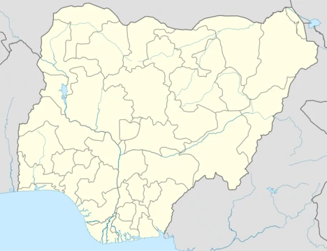
Delta State
Nigerian state formed from Bendel State on 27 August 1991.

via Wikipedia: Delta State · see source
Delta State is a state in the South-South geopolitical zone of Nigeria, named after the Niger Delta—a large part of which is in the state. Formed from the former Bendel State on 27 August 1991, it is bordered on the north by Edo State, the east by Anambra and Rivers states, the south by Bayelsa State, the west by Ondo State, and the Bight of Benin, which covers about 160 kilometres of the state's coastline. Its capital city is Asaba, located along the River Niger on the northeastern end of the state, while the state's economic center is the city of Warri on the southwestern coastline. Of the 36 states, Delta is the 23rd largest in area and twelfth most populous, with an estimated population of over 7.8 million as of 2024.
- Created
- 27 August 1991
- Capital
- Asaba
- Area
- 18,050 km²
- Population (2024 est.)
- over 7.8 million
- Geopolitical Zone
- South-South
- Major Economic Activity
- Crude oil and natural gas production
Verified Timeline
Lore & Background
Delta State was defined out of the former Bendel State on 27 August 1991, following agitations for a separate distinct state by the peoples of the old Delta Province. The military President, Gen. Ibrahim Babangida, recognized Delta State but chose Asaba as the capital city. The state was initially created with 12 local government areas in 1991, later expanded to 19, and now has 25. Geographically, the state is divided between the Central African mangroves in the coastal southwest and the Nigerian lowland forests in most of the rest of the state, with a small portion of the Niger Delta swamp forests in the far south. The River Niger and its distributaries, the Forçados River and the Escravos River, flow along the state's eastern and southern borders and through Warri. In the pre-colonial period, the area was divided into monarchial states like the Kingdom of Warri, Aboh, and Agbon Kingdom before becoming part of the British Oil Rivers Protectorate in 1884. Colonial forces did not gain permanent control until the 1910s due to the Ekumeku Movement. Notably, the UK leased the enclave of Forcados to France from 1903 to 1930. During the Nigerian Civil War, Biafran forces invaded the Mid-Western Region and briefly declared it the Republic of Benin; upon liberation, Nigerian forces committed the Asaba massacre against ethnic Igbos in Asaba. Economically, Delta State is based around the production of crude oil and natural gas as one of the main oil-producing states in the country, with minor industries involving agriculture such as oil palm, yam, and cassava crops along with fishing and heliciculture. In large part due to its vast oil revenues, Delta has the fourth highest Human Development Index in the country; however, disputes between oil companies and local communities along with years of systemic corruption have led to hostilities.
Reader's Guide
Delta State is significant as one of Nigeria's main oil-producing states, contributing substantially to the national economy through crude oil and natural gas. Its formation on 27 August 1991 from Bendel State reflects the ongoing process of state creation in Nigeria to address regional identities. The state has the fourth highest Human Development Index in the country, largely due to oil revenues, yet disputes between oil companies and local communities along with systemic corruption have led to hostilities tied to the lack of development in host communities. The state's diverse ethnic composition includes the Urhobo and Isoko in the centre, Anioma people to the north, and the Ijaw, Itsekiri, and Urhobo in the southwest. Historically, the area experienced colonial resistance through the Ekumeku Movement and a brief period of French control over the Forcados enclave from 1903 to 1930. The Asaba massacre during the Nigerian Civil War remains a significant and tragic event. Delta's geography, with its extensive coastline of about 160 kilometres, mangrove swamps, and Niger Delta distributaries, makes it ecologically important but also vulnerable to flooding—the state had a mean rainfall of 36.9 mm, with the highest rainfall in 2015 amounting to 3183.6 mm and the lowest in 2007 at 2030.58 mm. The state is generally low-lying without any remarkable hills, with a wide coastal belt inter-laced with rivulets and streams.
Did You Know?
- Delta State was initially created with 12 local government areas in 1991, later expanded to 19, and now has 25.
- The UK leased the enclave of Forcados to France from 1903 to 1930, making it one of the few parts of Nigeria under French control.
- During the Nigerian Civil War, Biafran forces briefly declared the captured Mid-Western Region (including now-Delta State) as the Republic of Benin.
- Delta State has the fourth highest Human Development Index in Nigeria, largely due to its vast oil revenues.
- The state's coastline along the Bight of Benin covers about 160 kilometres.
Geography & Natural Environment
Delta State sprawls across roughly 18,050 square kilometres in Nigeria's South-South zone, with over 60 percent of its territory as land. The terrain is notably flat, lacking any significant hills, and the landscape is dominated by a wide coastal belt threaded with countless rivulets and streams that collectively form much of the western Niger Delta. The River Niger traces the state's eastern boundary, while its distributaries—the Forçados and Escravos rivers—carve through the southern and southwestern reaches, the latter running directly through the city of Warri. The ecological mosaic shifts from Central African mangroves along the coastal southwest to Nigerian lowland forests across the interior, with a small pocket of Niger Delta swamp forests in the far south. This diversity supports threatened species including the dwarf crocodile, Grey parrot, African fish eagle, mona monkey, and African manatee, while offshore waters host Lesser African threadfin, blue mussels, and various cetacean species. The state's 160-kilometre coastline along the Bight of Benin underscores its deep maritime character.
Ethnic Tapestry & Pre-Colonial Sovereignty
Long before colonial boundaries were drawn, the territory now known as Delta State was home to a rich patchwork of ethnic communities. The Isoko and Urhobo peoples occupied the central regions, while the Anioma people settled to the north. In the southwest, the Ijaw, Itsekiri, and Urhobo communities coexisted in a complex social landscape. These groups organized themselves into sovereign monarchial polities, including the Kingdom of Warri, the Aboh Kingdom, and the Agbon Kingdom, each maintaining distinct governance structures. When British forces moved to establish the Oil Rivers Protectorate in 1884, local resistance proved fierce. The Ekumeku Movement, a sustained uprising, prevented the colonial administration from securing permanent control over much of the area until the 1910s.
Political Formation & Wartime Turmoil
The modern state of Delta was born on 27 August 1991, when military President Ibrahim Babangida split the former Bendel State, designating the southern portion as Delta and the northern portion as Edo. The capital, Asaba, was chosen as a prominent town along the River Niger in the northeastern reaches. The road to this configuration was turbulent. After Nigeria's 1960 independence, the area belonged to the Western Region until 1963, when it was transferred to the newly created Mid-Western Region. During the 1967 Biafran War, secessionist forces invaded the Mid-Western Region in a bid to capture Lagos; they briefly declared the captured territory the Republic of Benin before being pushed back. In the aftermath, Nigerian forces carried out the Asaba massacre against ethnic Igbos in the capital. The Mid-Western Region was reformed after reunification, renamed Bendel State in 1976, and finally divided in 1991 to produce today's Delta and Edo states.
Oil Wealth & the Development Paradox
Delta State anchors Nigeria's crude oil and natural gas production, making it one of the country's principal energy states. Beyond hydrocarbons, the economy draws on agriculture—particularly oil palm, yam, and cassava cultivation—as well as fishing and heliciculture. The state's capital, Asaba, sits along the River Niger in the northeast, while Warri on the southwestern coast serves as the economic engine. Despite its modest size—23rd largest of Nigeria's 36 states—Delta ranks fourth in the national Human Development Index, a figure largely attributable to its vast oil revenues. Yet this wealth has not translated into equitable development. Decades of disputes between petroleum companies and host communities, compounded by systemic corruption, have fueled persistent hostilities. The gap between the state's headline indicators and the lived reality of communities along the coast and in the interior remains a defining tension in Delta's contemporary story.
Gallery
Frequently Asked Questions
Who is Delta State?
Delta State is a state in Nigeria's South-South geopolitical zone, taking its name from the Niger Delta region. It was carved out of the former Bendel State on 27 August 1991, with Asaba as its capital and Warri as its economic hub.
What is Delta State's main role in the story?
Delta State functions as one of Nigeria's key crude oil and natural gas production hubs, making it a critical economic engine for the country. Its 18,050 km² of territory supports a population exceeding 7.8 million as of 2024 estimates.
How does Delta State's arc end?
Delta State has no narrative ending because it is a living, ongoing administrative unit rather than a finished story. It continues to operate as a sovereign state within Nigeria, with its oil economy and governance still very much in progress.
Why is Delta State important to the overall picture?
As a major oil-producing region, Delta State contributes disproportionately to Nigeria's energy output and national revenue. Its position in the South-South zone also makes it a cultural and economic crossroads linking the Niger Delta to the broader southern region.
How did Delta State come to exist?
Delta State was created on 27 August 1991 when the former Bendel State was split into two separate states. This administrative reorganization gave the Niger Delta region its own dedicated government headquartered in Asaba.
More in Nigerian States 1-24
Related in Nigerian States
Links follow this subject's own source article.
Elsewhere in the Nigerian States universe
Spotted an error? Know more?
This is a living reference — every entry is fact-audited, and reader corrections feed straight into our audit queue. Suggest an edit · See this site's audit record