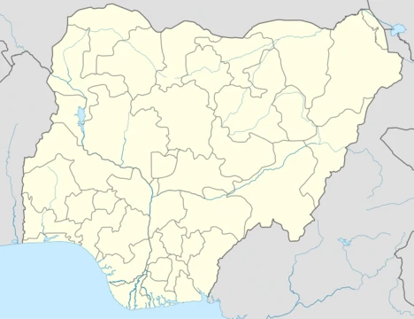
Niger State
Largest state in Nigeria, key in energy and agriculture.

via Wikipedia: Niger State · see source
Niger State is a state in the North Central region of Nigeria, bordered to the east by Kaduna State and the Federal Capital Territory, to the north by Kebbi State and Zamfara State, and to the south by Kogi and Kwara states, while its western border makes up part of the international border with Benin. It is the largest state in the country by area. The state capital is Minna, and the state is divided into 25 local government areas. Other major cities include Bida, Kontagora, and Suleja. Of the 36 states of Nigeria, Niger is the eleventh most populous with an estimated population of about 6.7 million as of 2020. The state is ethnically diverse, including communities of Adara, Fulani, Gbagyi, Hausa, Hun-Saare, Kambari, Kamuku, Koro Gungawa, Nupe, and other ethnic groups. Historically, parts of modern-day Niger State were centres of powerful pre-colonial states, including the Nupe Kingdom, Gbagyi states, and parts of the Hausa Bakwai states. In the early nineteenth century, parts of the state were incorporated into the Sokoto Caliphate following the Fulani jihad. With British colonisation in the early 1900s, the area became part of the Northern Nigeria Protectorate. Upon Nigeria's independence in 1960, Niger State was initially part of the Northern Region until 1967, when it became part of the North-Western State. In 1976, Niger State was created as a distinct entity following the breakup of North-Western State and in the 1990s, the state gained the Borgu region from Kwara. Since the late 2010s, Niger has been one of the states hit hardest by banditry and terrorism. Economically, Niger State is largely driven by agriculture along with livestock farming and herding. The state plays a key role in Nigeria's energy sector due to its hydroelectric dams. Niger State has the tenth-highest GDP in the country but has a low Human Development Index ranking.
- Capital
- Minna
- Area
- Largest state in Nigeria by area
- Population
- Approximately 6.7 million as of 2020
- Major Rivers
- Niger and Kaduna rivers
- Major Dams
- Kainji, Jebba, and Shiroro Dams
- National Park
- Kainji National Park, the largest in Nigeria
- GDP Rank
- Tenth-highest GDP in Nigeria
Verified Timeline
Lore & Background
Niger State was created in 1976 from the breakup of North-Western State, and later gained the Borgu region from Kwara in the 1990s. Its territory includes areas that were once part of the Nupe Kingdom, Gbagyi states, and Hausa Bakwai states before being incorporated into the Sokoto Caliphate in the early nineteenth century. During British colonization in the early 1900s, the area became part of the Northern Nigeria Protectorate, and after Nigeria's independence in 1960, it was part of the Northern Region until 1967, then North-Western State until 1976. The state is governed by a democratically-elected governor, currently Mohammad Umar Bago, who works with the Niger State House of Assembly. The state has three Senatorial Zones: Niger East, Niger North, and Niger South. The governor is selected using a modified two-round system requiring a plurality and over 25% of the vote in at least two-thirds of local government areas.
Reader's Guide
Niger State is significant as Nigeria's largest state by area and a major contributor to the country's energy sector through its hydroelectric dams—Kainji, Jebba, and Shiroro—which provide substantial power. The state also hosts Kainji National Park, the largest national park in Nigeria, encompassing Kainji Lake and the Borgu and Zugurma Game Reserves. Economically, Niger State is driven by agriculture, livestock farming, and herding, and it holds the tenth-highest GDP in Nigeria, though its Human Development Index ranking is low. The state's diverse ethnic composition includes Adara, Fulani, Gbagyi, Hausa, Hun-Saare, Kambari, Kamuku, Koro Gungawa, Nupe, and others. Historically, it was a center of pre-colonial states and later part of the Sokoto Caliphate and British Northern Nigeria Protectorate. Since the late 2010s, Niger has been heavily affected by banditry and terrorism. Its transport infrastructure includes federal highways, railways, and Minna Airport, supporting connectivity within Nigeria and to Benin.
Did You Know?
- Niger State is the largest state in Nigeria by area.
- The state is home to Kainji National Park, the largest national park in Nigeria.
- Niger State has three major hydroelectric dams: Kainji, Jebba, and Shiroro.
- The state was created in 1976 from the breakup of North-Western State.
- Niger State gained the Borgu region from Kwara State in the 1990s.
Frequently Asked Questions
What is Niger State?
Niger State is one of Nigeria's 36 states, situated in the North Central region. It holds the distinction of being the country's largest state by land area and is bordered by Kaduna, Kebbi, Zamfara, Kogi, Kwara, and the Federal Capital Territory, with its western edge forming part of the international border with Benin.
What is the capital of Niger State?
Minna serves as the state capital. The state is further divided into 25 local government areas, with Bida, Kontagora, and Suleja among its other notable cities.
What major rivers and dams are found in Niger State?
The Niger and Kaduna rivers flow through the state, and it hosts three significant hydroelectric dams: Kainji, Jebba, and Shiroro. Kainji National Park, located within the state, is the largest national park in Nigeria.
How populous is Niger State?
As of 2020, the state had an estimated population of roughly 6.7 million people, making it the eleventh most populous among Nigeria's 36 states.
Why is Niger State important to Nigeria?
The state plays a critical role in the nation's energy sector through its major hydroelectric dams and supports agricultural production across its vast territory. Its size and resource base make it a key contributor to Nigeria's infrastructure and food supply.
More in Nigerian States 1-24
Elsewhere in the Nigerian States universe
Spotted an error? Know more?
This is a living reference — every entry is fact-audited, and reader corrections feed straight into our audit queue. Suggest an edit · See this site's audit record